
Deep Creek Lake State Park: Thayer Trace Trail

Deep Creek Lake State Park: Thayer Trace Trail

Trail System: Deep Creek Lake State Park
Distance:
5.1 km
Activities: Mountain Bike, E-bike, Hike, Trail Running
Difficulty: Very Difficult
Climb: 130 m
Descent: -116 m

Going clockwise from the top, the first section winds through a forest and doesn’t change elevation a lot, but it flows well over large rocks in some places. There are a few spots where you’ll want to watch your bars on the trees and time your pedal strokes, but it isn’t too technical. Once you start losing elevation, there are some line options through rockier sections, but it’s generally pretty easy to stay on the right line.

The switchbacks are tight, and some of them have large rocks with uneven placement, so you may have to search for the right lines there. Before you reach the bottom, there is a straightaway bench-cut along a slope with some rollers that you can pump to really gain speed. There is a switchback soon after that, so watch your speed until you’re familiar with it. Coming back up from the connector, the climb isn’t too difficult. The switchbacks are wider and banked more, so it may be well worth riding counterclockwise as well.

Completed in late summer 2019. 

Address: 898 State Park Road, Swanton, Maryland 21561​​
Driving & Parking Directions:
 Check the map below.
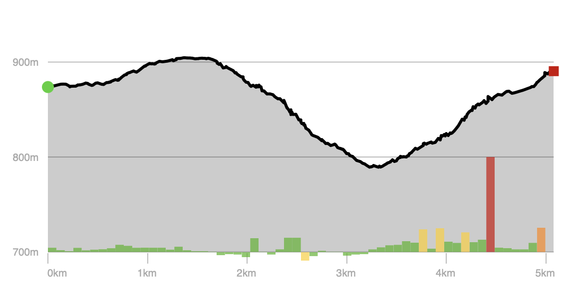
Elevation Profile - Thayer Trace Trail (Deep Creek Lake State Park)

Wisp Resort – East Ridge Trails: Odin’s Chute

Wisp Resort - East Ridge Trails: Odin's Chute

Trail System: Wisp Resort – East Ridge Trails
Distance:
326 m
Activities: Downhill Ski
Difficulty: Very Difficult
High Point: 929 m
Descent: -46 m

Odin’s Chute is a 1,070 ft black diamond ski run (piste) trail located near McHenry, Maryland. This downhill ski only trail can be used in both directions.

Address: 296 Marsh Hill Rd, McHenry, MD 21541
Driving & Parking Directions:
 Check the map below.
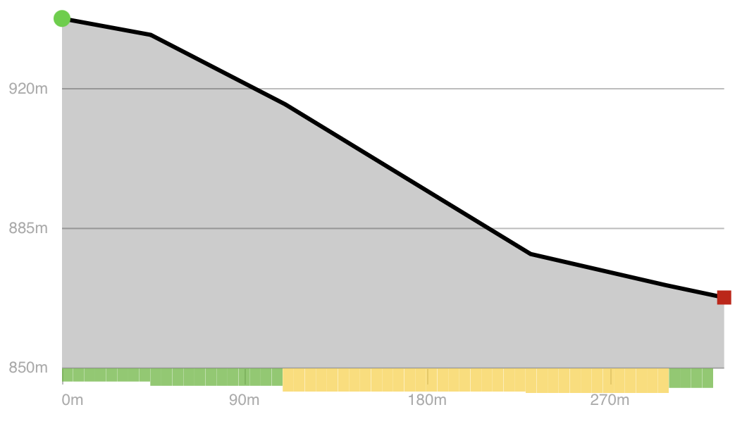
Wisp Resort - East Ridge Trails: Odin's Chute

Wisp Resort – East Ridge Trails: Main Street

Wisp Resort - East Ridge Trails: Main Street

Trail System: Wisp Resort – East Ridge Trails
Distance:
586 m
Activities: Downhill Ski
Difficulty: Very Difficult
High Point: 865 m
Descent: N/A

Main Street is a 1,923 ft black diamond ski run (piste) trail located near McHenry, Maryland. This downhill ski only trail can be used in both directions.

Address: 296 Marsh Hill Rd, McHenry, MD 21541
Driving & Parking Directions:
 Check the map below.
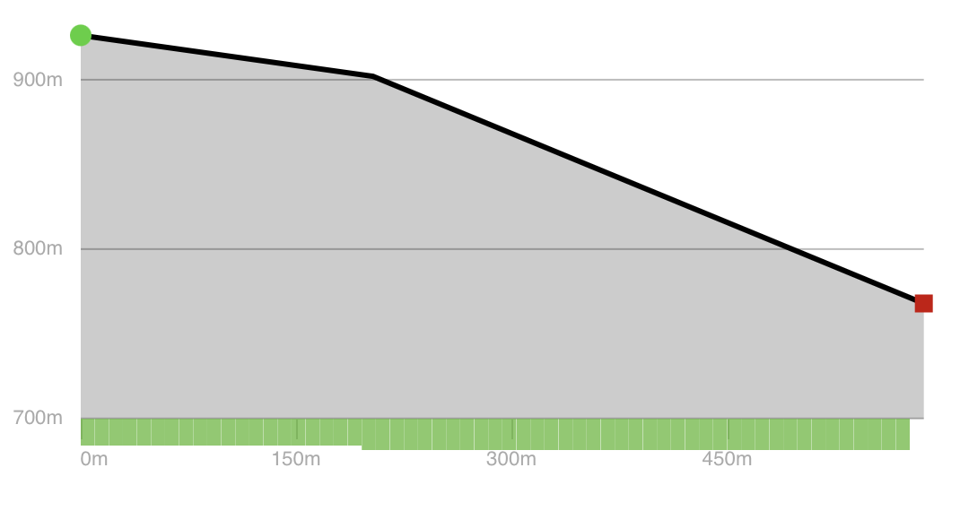
Wisp Resort - East Ridge Trails: Main Street

Wisp Resort – East Ridge Trails: Highline Pass

Wisp Resort - East Ridge Trails: Highline Pass

Trail System: Wisp Resort – East Ridge Trails
Distance:
171 m
Activities: Downhill Ski
Difficulty: Very Difficult
High Point: 880 m
Descent: -7 m

Highline Pass is a 561 ft black diamond ski run (piste) trail located near McHenry, Maryland. This downhill ski only trail can be used in both directions.

Address: 296 Marsh Hill Rd, McHenry, MD 21541
Driving & Parking Directions:
 Check the map below.
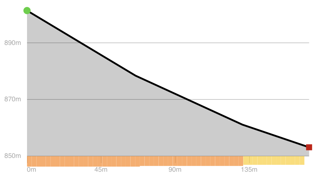
Wisp Resort - East Ridge Trails: Highline Pass

Wisp Resort – East Ridge Trails: Eye Opener

Wisp Resort - East Ridge Trails: Eye Opener

Trail System: Wisp Resort – East Ridge Trails
Distance:
661 m
Activities: Downhill Ski
Difficulty: Very Difficult
High Point: 915 m
Descent: -116 m

Eye Opener is a 2,169 ft black diamond ski run (piste) trail located near McHenry, Maryland. This downhill ski only trail can be used in both directions.

Address: 296 Marsh Hill Rd, McHenry, MD 21541
Driving & Parking Directions:
 Check the map below.

Wisp Resort - East Ridge Trails: Eye Opener

Wisp Resort – North Camp Trails: Over the Edge

Wisp Resort - North Camp Trails: Over the Edge

Trail System: Wisp Resort – North Camp Trails
Distance:
485 m
Activities: Downhill Ski
Difficulty: Very Difficult
High Point: 841 m
Descent: -59 m

Over the Edge is a 1,591 ft black diamond ski run (piste) trail located near McHenry, Maryland. This downhill ski only trail can be used in both directions.

Address: 296 Marsh Hill Rd, McHenry, MD 21541
Driving & Parking Directions:
 Check the map below.
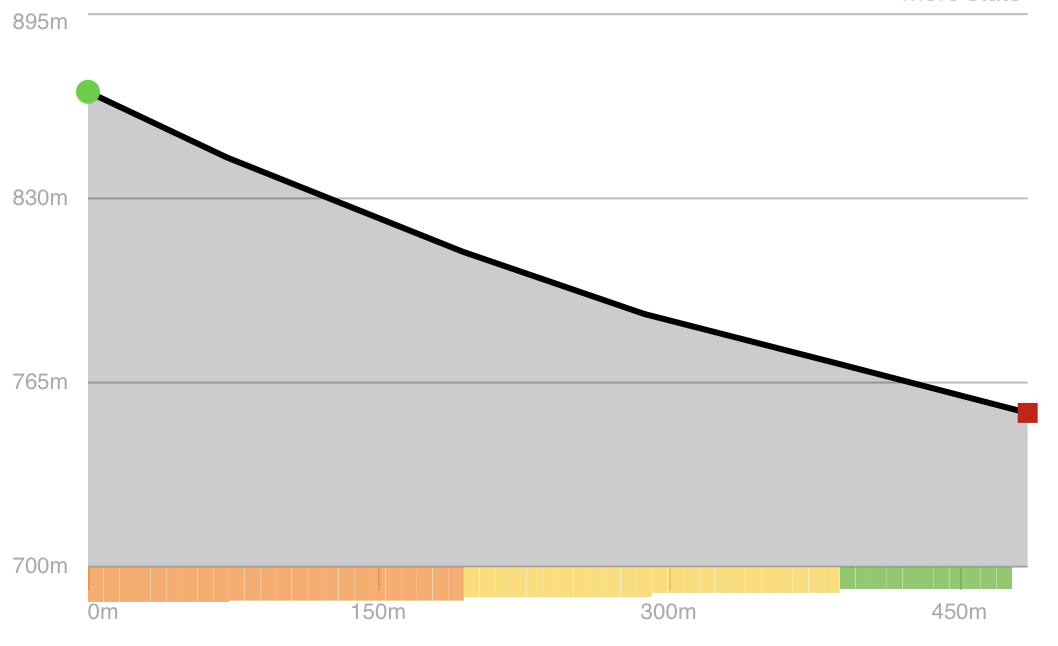
Wisp Resort - North Camp Trails: Over the Edge

Wisp Resort – Front Side Trails: Central Park Terrain

Wisp Resort - Front Side Trails: Central Park Terrain

Trail System: Wisp Resort – Front Side Trails
Distance:
290 m
Activities: Downhill Ski
Difficulty: Very Difficult
High Point: 817 m
Descent: -11 m

Central Park Terrain Park is a 951 ft black diamond ski run (piste) trail located near McHenry, Maryland. This downhill ski only trail can be used in both directions.

Address: 296 Marsh Hill Rd, McHenry, MD 21541
Driving & Parking Directions:
 Check the map below.
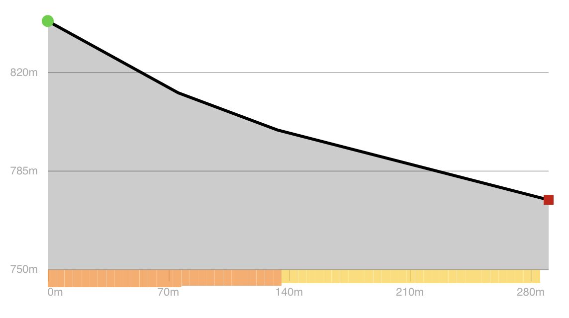
Wisp Resort - Front Side Trails: Central Park Terrain

Wisp Resort – Front Side Trails: The Face

Wisp Resort - Front Side Trails: The Face

Trail System: Wisp Resort – Front Side Trails
Distance:
403 m
Activities: Downhill Ski
Difficulty: Very Difficult
High Point: 833 m
Descent: N/A

The Face is a 1,322 ft black diamond ski run (piste) trail located near McHenry, Maryland. This downhill ski only trail can be used in both directions.

Address: 296 Marsh Hill Rd, McHenry, MD 21541
Driving & Parking Directions:
 Check the map below.
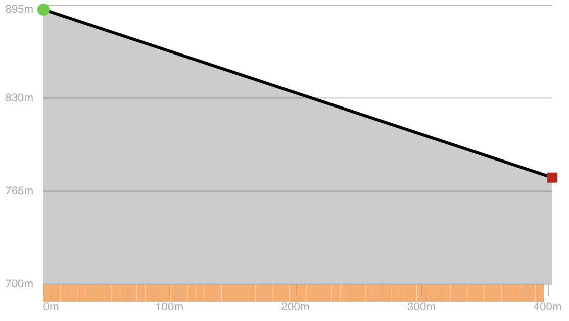
Wisp Resort - Front Side Trails: The Face

Wisp Resort – Front Side Trails: Squirrel Cage

Wisp Resort - Front Side Trails: Squirrel Cage

Trail System: Wisp Resort – Front Side Trails
Distance:
412 m
Activities: Downhill Ski
Difficulty: Very Difficult
High Point: 833 m
Descent: N/A

Squirrel Cage is a 1,352 ft black diamond ski run (piste) trail located near McHenry, Maryland. This downhill ski only trail can be used downhill only.

Address: 296 Marsh Hill Rd, McHenry, MD 21541
Driving & Parking Directions:
 Check the map below.
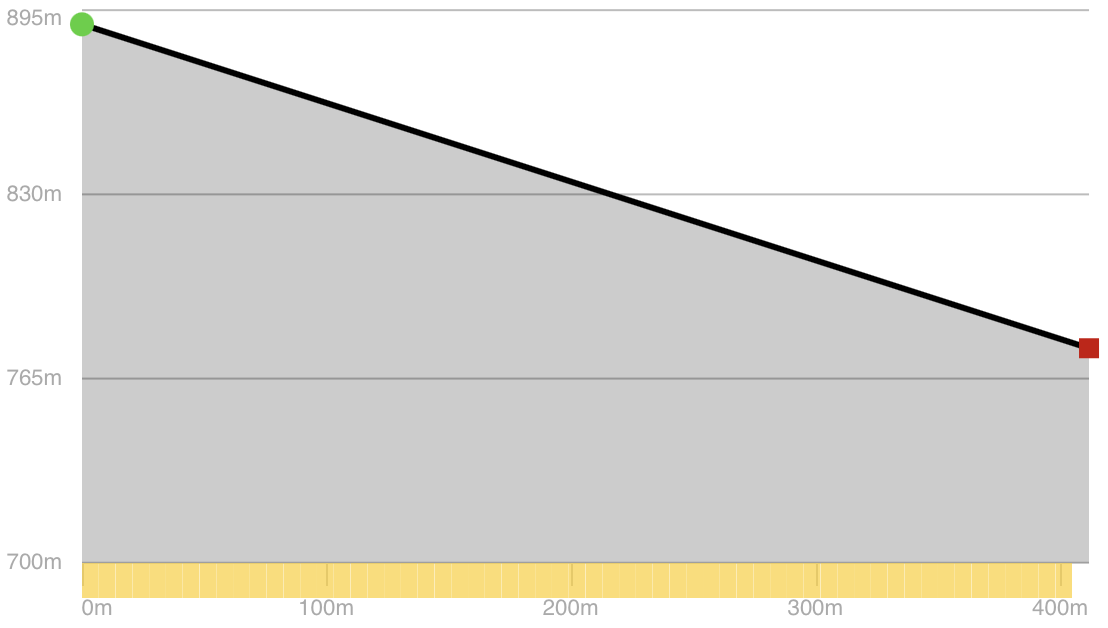
Wisp Resort - Front Side Trails: Squirrel Cage