

Originally published by AccuWeather.
A large winter storm will bring significant icy impacts, including dangerous travel conditions and some business interruption to parts of the Midwest, Great Lakes, mid-Atlantic and Northeast from Wednesday through Thursday.
“A clash of warm, humid air and cold Arctic air will result in a myriad of impactful weather for millions of Americans this week,” AccuWeather Meteorologist Brandon Buckingham said. “A dangerous ice storm and accumulating snow are expected between Wednesday and Thursday as a storm races east.”
Dangerous snow and ice storm impacts
Significant impacts from ice and snow are expected on the colder side of the winter storm across a large swath of the Great Lakes, central Appalachians, the Northeast and parts of the mid-Atlantic, which could affect more than 94 million people.

AccuWeather expert meteorologists are forecasting an area of 1-3 inches of snow from eastern Montana into northern Michigan on Wednesday. A zone of 3-6 inches of snow is expected from northern North Dakota into the Upper Peninsula of Michigan with an AccuWeather Local StormMax™ of 10 inches.
An icy buildup to an accumulation of 0.25 of an inch or more of ice could occur along the Interstate 80 and 94 corridors in parts of Wisconsin, Illinois, Michigan, Indiana, and Ohio on Wednesday.
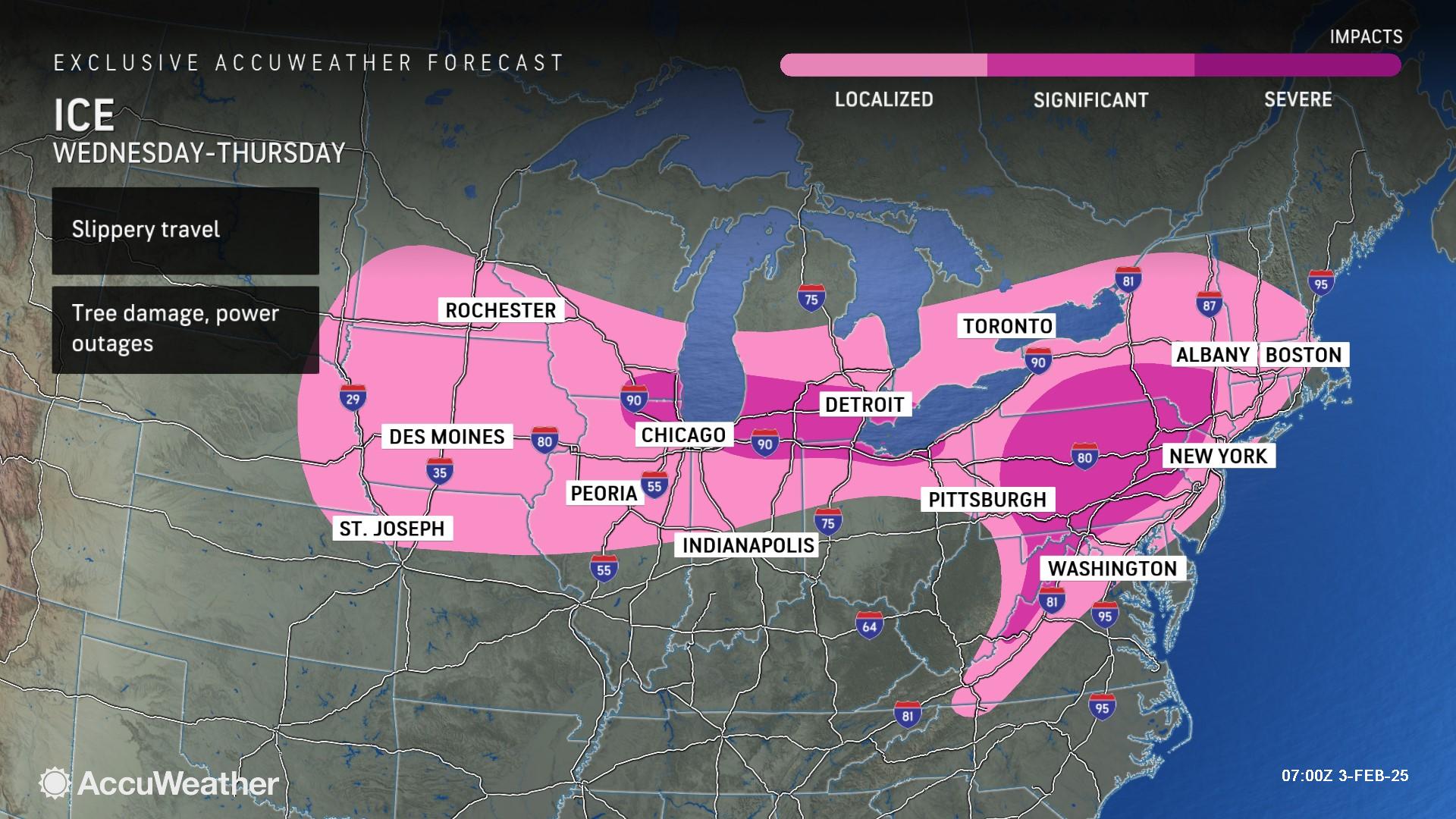
Significant ice storm impacts are expected across a portion of the central Appalachians, through northern Pennsylvania and southern New York. Accumulations of up to half an inch of ice are possible in some spots.
While the main event will be ice, there could be a narrow band of snow that develops Wednesday across Pennsylvania ahead of the ice storm. This snow band could bring a few inches of snow, most likely between I-80 and the border between Pennsylvania and Maryland.

“As the mild air mass clashes with frigid air farther north, the ingredients for a major ice storm are expected to be in place beginning Wednesday across a zone spanning from the Midwest to the Great Lakes,” Buckingham explained. “The potential exists for dangerous amounts of ice accretion into Thursday. This poses a risk for tree damage and power outages as the storm moves through.”
Areas including Harrisburg, Scranton, State College and Williamsport in Pennsylvania, Binghamton in New York and Cumberland in Maryland face the risk of dangerous to nearly impossible travel conditions at times, downed tree limbs and extended power outages.
A much larger area extending as far south and east as the I-95 corridor from Washington to Baltimore, Philadelphia, New York, Boston and upstate New York is expected to see a briefer period of icing before a changeover to rain. Areas farther north near the Canadian border are expected to get a period of accumulating snowfall before icing.
“Ice storms are incredibly dangerous. A light glaze of ice can create treacherous driving conditions on bridges, highways and ramps in a matter of seconds. Travel on the roads could be virtually impossible at times in the hardest-hit areas. Road and highway closures are possible, which would impact business operations and supply chain logistics,” AccuWeather Chief Meteorologist Jonathan Porter said. “A half inch of ice accumulation can add 500 pounds of extra weight or more to power lines. Tree branches coated in ice can snap and fall on power lines. Families and businesses should be prepared for the risk of extended power outages that could leave them without heat and utilities for several days after the storm.”
AccuWeather expert meteorologists say 1-3 inches of snow is expected in parts of northeastern Pennsylvania, eastern New York, northern Connecticut, western and central Massachusetts, as well as Vermont, New Hampshire and Maine. Pockets of 3-6 of snow are possible in higher elevations, with an AccuWeather Local StormMax™ of 9 inches.

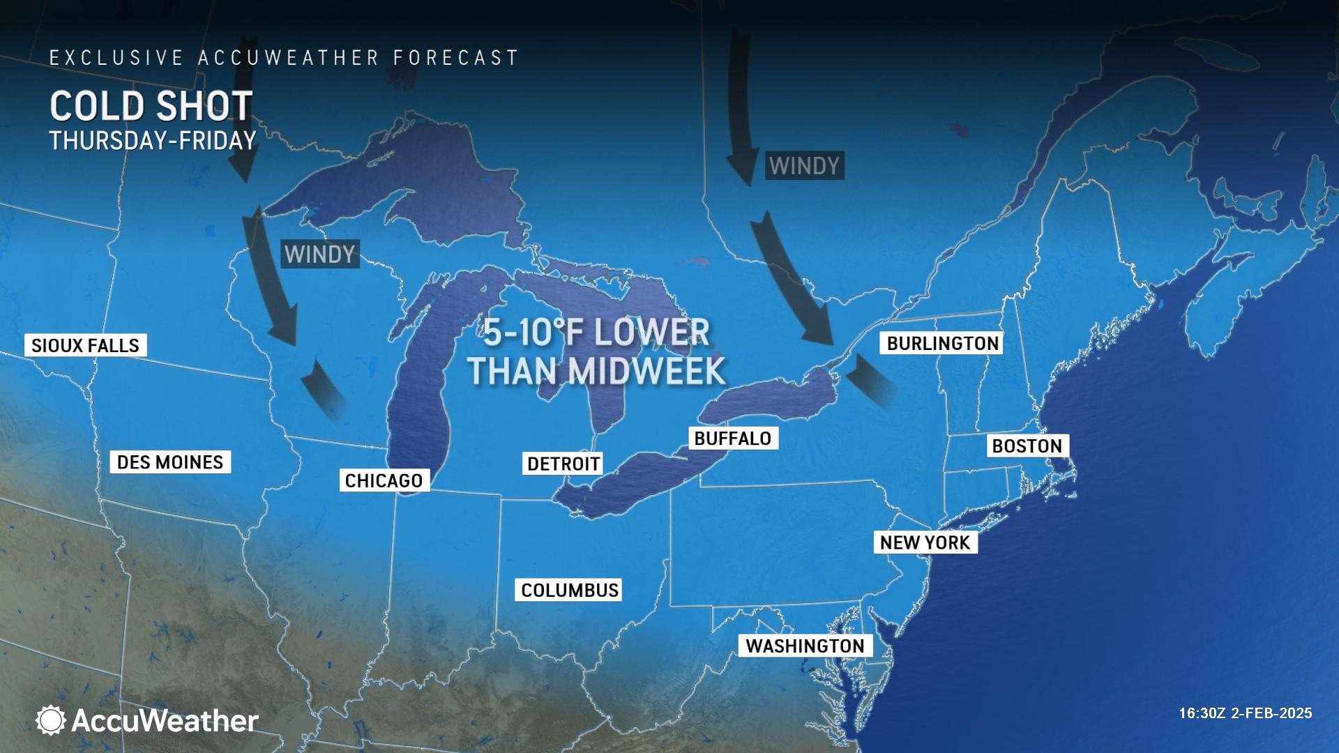
Colder air and gusty winds on the backside of the storm could compound the dangerous impacts of an ice storm, which can complicate efforts to restore power and treat icy roads.
Stormy start to February
AccuWeather’s team of long-range experts has been forecasting a stormy pattern in the first half of February since mid-January, long before Punxsutawney Phil saw his shadow on Groundhog Day and predicted six more weeks of winter.

AccuWeather Lead Long-Range Expert Paul Pastelok says a second winter storm will follow this midweek storm, with snow and ice impacting some of the same areas starting Friday through the weekend.
A third storm is possible early next week, with the potential of colder air and more moisture that could bring snow and icy impacts to a larger area.
AccuWeather expert meteorologists will provide forecast updates on the winter storm threats throughout the week.