Originally published by AccuWeather.
- AccuWeather expert meteorologists expect Beryl to maintain its strong intensity as it moves west of the Windward Islands through Monday afternoon.
- Beryl could bring some rain and wind impacts to southern Texas this weekend with a lower risk of impacts from Houston and points east.
- A new tropical threat could bring more flooding rainfall to islands hit hard by Hurricane Beryl later this week.
Hurricane Beryl slammed the Grenada Island of Carriacou with 140 mph sustained winds and a powerful storm surge Monday morning.
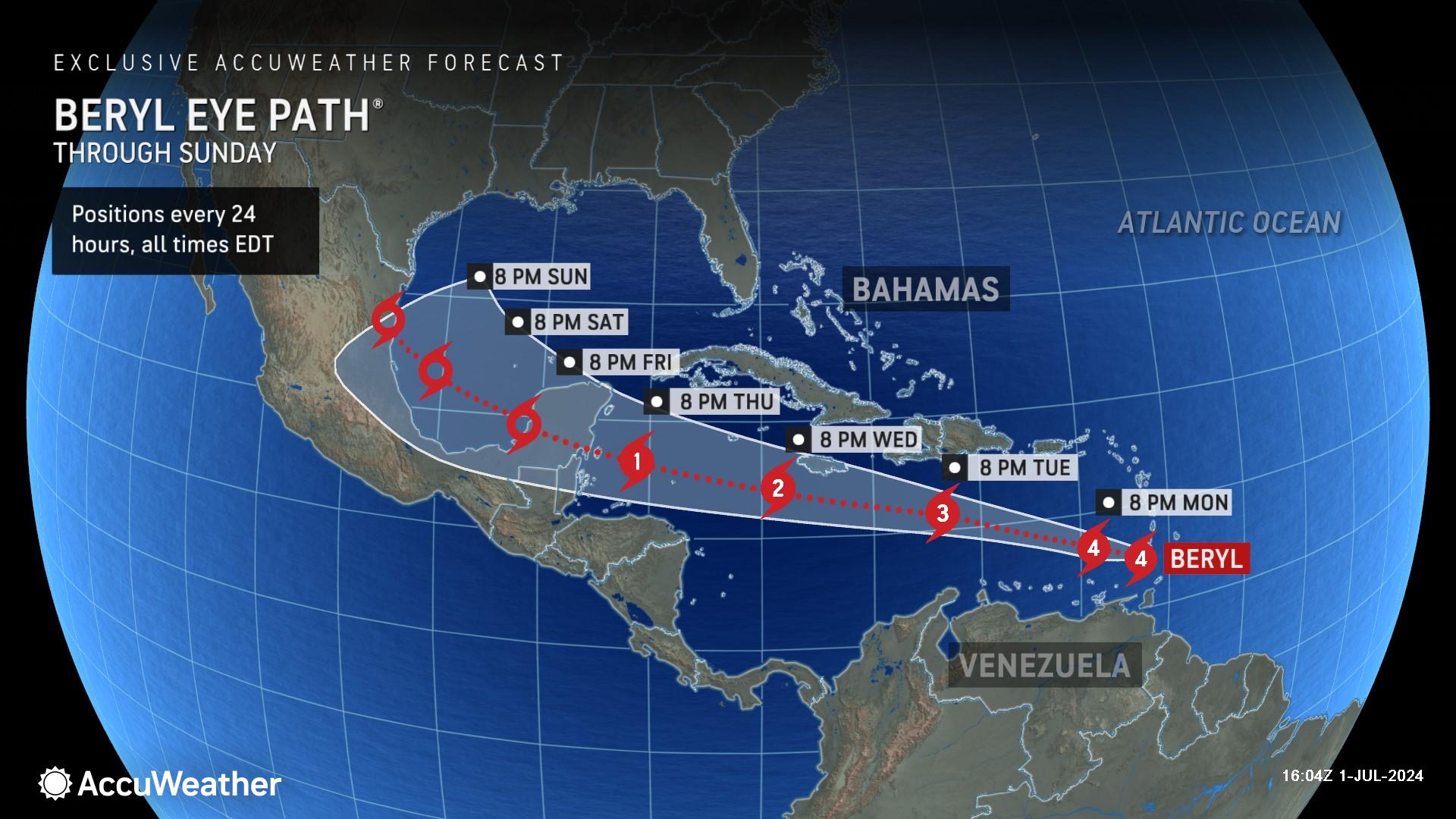
AccuWeather expert meteorologists say Beryl remains a dangerous Category 4 hurricane with sustained winds of 150 mph as it moves into the Caribbean Sea.
Beryl even approached Category 5 strength on Monday afternoon. A Category 5 hurricane has sustained winds of 157 mph or higher.
Destructive winds ripped off roofs, tore apart homes and knocked out power and internet connectivity across much of Carriacou.
AccuWeather Lead Hurricane Forecaster Alex DaSilva says Beryl is the strongest hurricane to develop this early in the season in this region of the Atlantic basin. Beryl is also the strongest hurricane in the record books to cross Grenada and portions of Saint Vincent and the Grenadines.
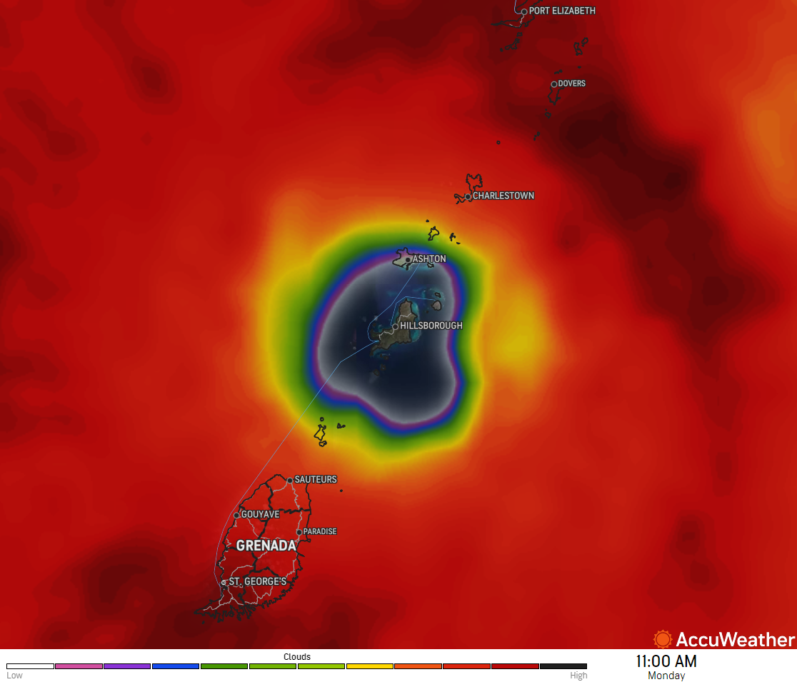
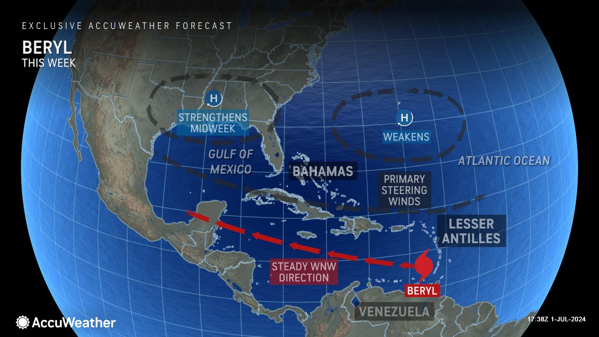
“This was essentially a worst-case scenario for the southern Grenadines. The wind field expanded, and wind speeds intensified before Beryl made landfall,” said DaSilva. “Beryl continues to strengthen as it moves through the Lesser Antilles, as the environment around the storm is becoming more favorable for intensification. The storm will continue to be steered west-northwestward across the Caribbean Sea by a large area of high pressure through the middle of this week.”
DaSilva says Beryl may encounter disruptive wind shear as the system moves toward the western part of the Caribbean. Interaction with the larger and mountainous islands of the region, in addition to increasing wind shear, may cause Beryl to lose wind intensity as drier air gets pulled into the storm from downsloping winds. However, it will likely remain a dangerous hurricane through the Caribbean.
Water temperatures well above the historical average are supporting the hurricane’s intensity in the short term.
“This is still a rather compact storm, but it’s incredibly powerful,” said DaSilva.
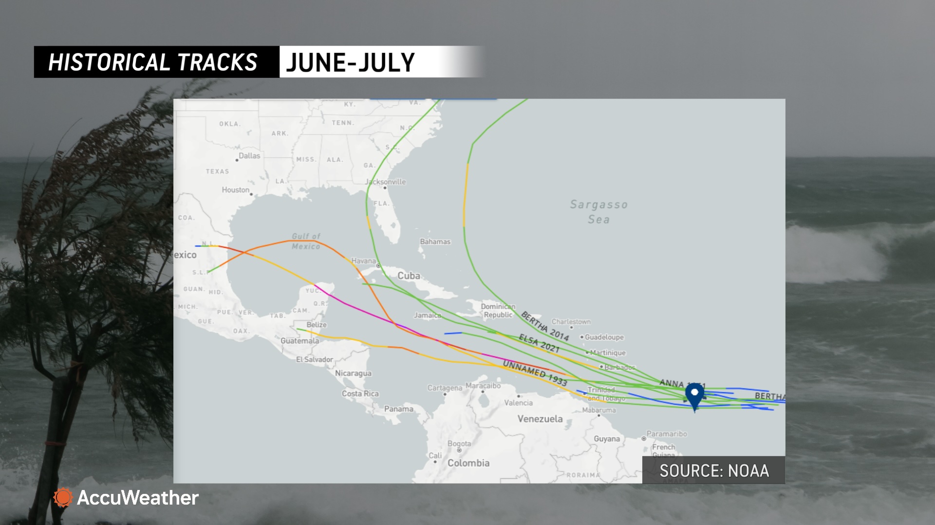
Tropical storms and hurricanes in the central and eastern Atlantic are rare this early in the season. This area of the Atlantic, known as the Main Development Region, does not typically spawn tropical storms and hurricanes until mid-August or later.
Where is Hurricane Beryl headed next?
Jamaica is the next island in the path of Beryl. AccuWeather expert meteorologists say the center of Hurricane Beryl is expected to pass to the south of Jamaica on Wednesday as a Category 2 hurricane, but it still has the potential to bring significant impacts.
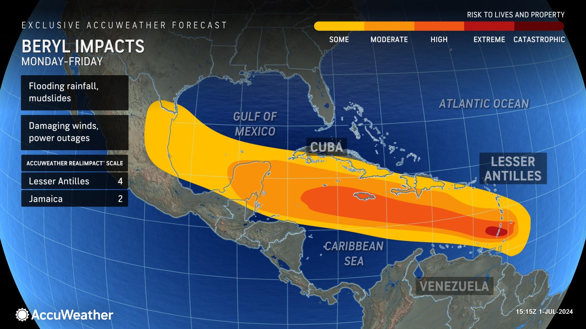
The AccuWeather RealImpact™ Scale for Hurricanes is a 2 for Jamaica, which warns of moderate flooding and significant wind damage to small buildings and trees, as well as power outages and property damage from coastal inundation.
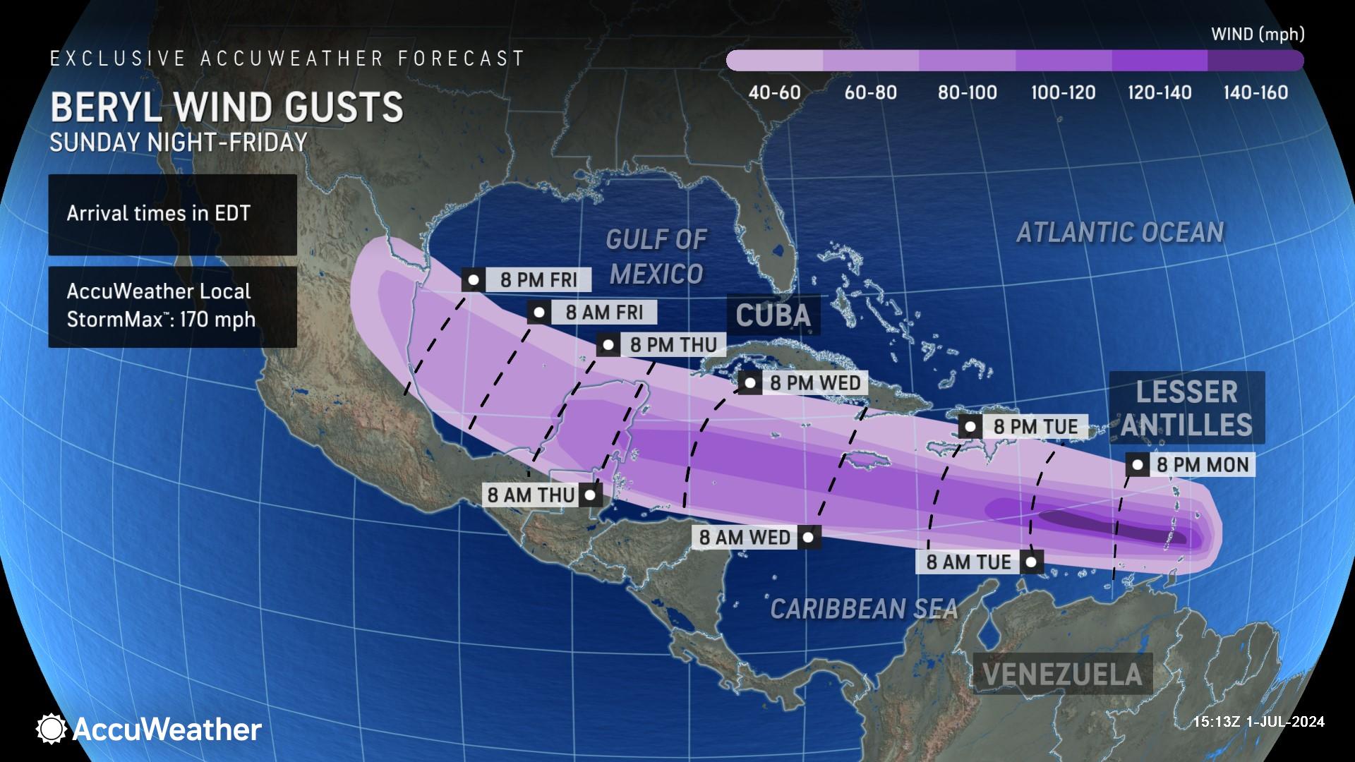
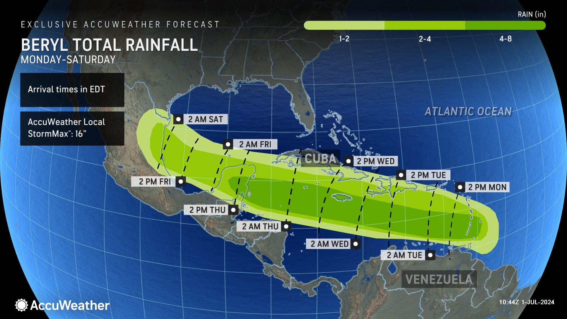
AccuWeather expert meteorologists say Beryl is expected to make a second landfall in the Yucatan Peninsula of Mexico on Thursday night or Friday morning as a Category 1 hurricane. Beryl is then forecast to cross the Bay of Campeche before making a third landfall in northeastern Mexico this weekend or early next week.
At this time, AccuWeather expert meteorologists say there is a low chance that Beryl would have direct impacts on the United States with the greatest chance from Corpus Christi, Texas, on south. Downpours are possible in southern Texas even with a landfall in northern Mexico.
DaSilva is warning people along the U.S. Gulf Coast not to let their guard down.
“It is very important to note that if the high pressure across the Southeast weakens, that can allow the storm to move farther north and potentially directly impact the Gulf Coast,” explained DaSilva.
For this reason, AccuWeather meteorologists have included South Texas in the potential ‘window of movement,’ with some risk to lives and property in the region.
If the track shifts north, heavy rainfall and flooding would be a concern in South Texas this weekend.
Impacts are not expected along the Southeast U.S. coast or in Florida.
“AccuWeather’s team of more than 100 experts have cleared the East Coast of the United States and Florida from any direct impacts from Hurricane Beryl,” said AccuWeather Chief On-Air Meteorologist Bernie Rayno.
Yet another tropical threat on the horizon
AccuWeather expert meteorologists are referring to another area of likely development to the east of Hurricane Beryl as a tropical rainstorm, with the expectation that it may strengthen into yet another tropical storm before reaching the Windward Islands.
While AccuWeather cannot rule out this storm reaching hurricane strength before tracking into the Caribbean, conditions are not as conducive as they were with Beryl.
“This storm is expected to follow a track very similar to Beryl and can be near the Lesser Antilles around July 3-4. The storm could eventually bring heavy rain and strong winds to portions of the Greater Antilles,” warned DaSilva.
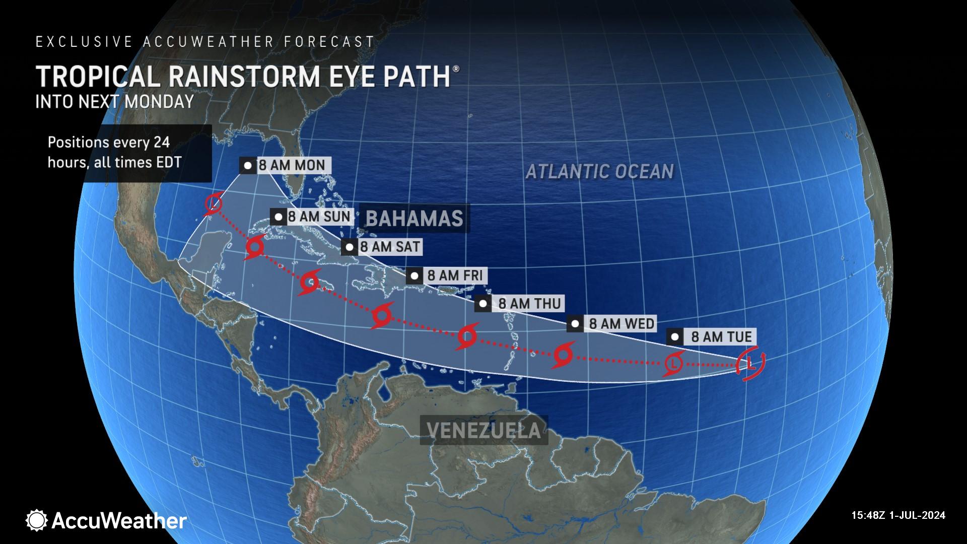
AccuWeather Flood Expert Alex Sosnowski says this tropical rainstorm is not currently expected to reach the high intensity that Beryl has, but it will likely complicate clean-up and recovery efforts on islands that were just impacted by Beryl.
“Beryl caused considerable damage to buildings and infrastructure, such as water, sewer and electrical services. The hurricane likely displaced many people on portions of the Windward Islands. This new system could bring much more damage, dangerous conditions, and disruptions than a mere tropical storm might do without Beryl’s wrath,” explained Sosnowski. “Roads and storm drains that are clogged with debris may flood more easily in the wake of Beryl. Weakened buildings may be further damaged by rain and gusty winds from the new system. In the hardest– hit communities, it may take many months or even years to recover from Beryl, let alone additional damage caused by the next tropical threat. At the very least, the new storm and its heavy rain and gusty winds will hamper recovery and clean-up operations.”
Sosnowski says the back-to-back tropical impacts would be a major blow to the tourism industry in the Caribbean.
Prepare for ‘explosive’ hurricane season
AccuWeather expert meteorologists say families, businesses, and officials need to be prepared for a flurry of tropical threats in the coming months.
AccuWeather was the first known source to issue a forecast on June 27 for what would become Beryl, warning of hurricane impacts in the Caribbean. Expert meteorologists at AccuWeather’s Global Weather Center sounded the alarm in March of an ‘explosive’ hurricane season.
AccuWeather is forecasting 20-25 named storms and four to seven major hurricanes.

Beryl is the first major hurricane of the season.
DaSilva warned in March of the potential of more than 30 named storms this season, which would break the all-time record set in 2020.