Originally published by AccuWeather.
Tropical trouble could be brewing along the East Coast this week, and it can lead to a weekend washout for some in the East. A storm is expected to form off the Southeast coast, and it could become a tropical storm or a subtropical storm later this week. Regardless of status, it has the potential to bring heavy rain and an increased flood risk across a widespread region from northeastern Florida to at least the mid-Atlantic and possibly the Northeast from Friday through the weekend. With how wet it has been in some of these areas in recent weeks, and on top of some heavy rain that fell from Lee over eastern New England this past weekend, flooding will be a prime concern. Gusty onshore winds are also expected from the Southeast coast to the Jersey Shore. This will promote rough surf and rip currents along with some coastal flooding and beach erosion. Fortunately, the current lunar cycle (first quarter on Friday) will not further amplify coastal flooding concerns.
While not currently the most likely scenario, it is possible that the area of low pressure could develop into a stronger tropical storm. In this case, more wind impacts such as downed trees and powerlines would be likely near the point of landfall.
Said AccuWeather Chief Meteorologist Jonathan Porter, “With the risk of heavy rain will come the possibility of urban and flash flooding, travel disruptions as well as delays or cancellations to outdoor plans such as ball games, weddings or family gatherings. If you have plans to travel or for outdoor events later this week or this weekend in the East we strongly recommend keeping an eye on our detailed forecast.”
Porter also said, “Confidence is high that an area of low pressure will produce heavy rain across portions of the Southeast and mid-Atlantic late this week and into the weekend. The exact timing and amount of rain will depend on the forward. speed of the tropical moisture surging northward. It is also possible that the heavy rain will reach the Northeast, including New England, on Saturday or Sunday. This region has been recently soaked by rounds of rain with some locations from Delmarva through southern New England receiving 2 to 3 times their historical average over the last two weeks. The pre-existing soggy conditions make these areas more prone to flooding should the heavy rain make it that far north. Regardless, outdoor plans are likely to be impacted starting Friday in the Southeast and then in the mid-Atlantic on Saturday.”
The storm is likely to form along a stalled frontal boundary in the area. “Stalled fronts along the southeastern coast of the United States are one way a ‘homebrew’ tropical system can form,” AccuWeather Chief On-Air Meteorologist Bernie Rayno said.
The storm will be developing over the Gulf Stream, a current that originates from the Caribbean, and transports warm water along much of the East Coast. Water temperatures in this zone are currently well into the 80s and well above the minimum threshold needed for tropical development to take place.
AccuWeather forecasters say the question is whether the low-pressure area will have enough time to develop fully into a tropical system before it is pushed inland over the Carolinas this weekend.
“There will be stiff southerly breezes [wind shear] a few thousand miles above the surface in this zone,” AccuWeather Senior Meteorologist Adam Douty said. “Not only might the wind shear inhibit full tropical development, it may also push the system onshore swiftly and essentially end the development process.” The wind shear is likely to prevent strengthening into a hurricane, Rayno said.
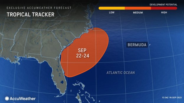
Factoring in all atmospheric conditions that will favor vs. hinder development, AccuWeather meteorologists believe there is a medium chance for a tropical depression and/or storm to form along the southeast U.S. coast from Friday to Sunday.
“It is possible that even if the center of the storm manages to linger right along the coast, heavy rain and thunderstorms associated with the system will be forced northward along the Carolina and mid-Atlantic coast from Friday to Saturday,” Douty said.
The rain may continue to advance into upstate New York and part of New England from Saturday night to Sunday.
There is also the possibility that a storm system rolling in from the Midwest could pull in moisture from the budding Atlantic system, further enhancing rainfall and perhaps spreading wet weather as far west as the central Appalachians.
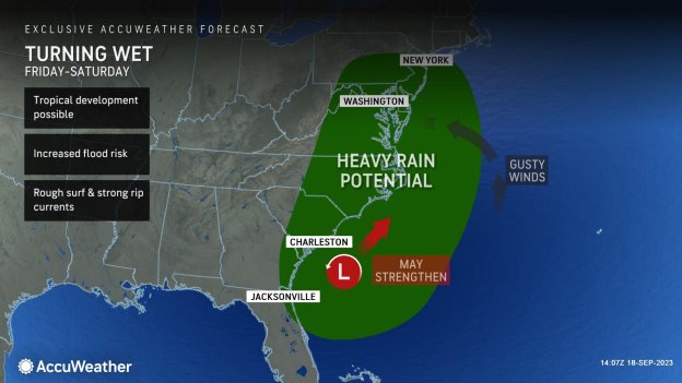
In general, the period from Friday to Sunday could be quite stormy along the coast from the Carolinas to southern New England due to stiff winds that will kick up seas and create strong rip currents as well as the risk of heavy rain and gusty thunderstorms, Douty said. So, yet another tropical system could spoil some weekend fun at the beach.
Parts of New England will be sensitive to additional rainfall.
Forecasters say that recent rainfall across nearby parts of southern New England over the previous week may heighten concerns for high water and transportation delays.
“Not only is eastern Maine vulnerable to flooding early this week, but areas in Connecticut, Rhode Island and eastern Massachusetts will also be at risk for localized flooding,” explained AccuWeather Meteorologist Alex DaSilva.
Between the 8th and the 13th of September, locations such as Hartford, Connecticut, and Pawtucket, Rhode Island, just a few miles to the northeast of Providence, recorded roughly 150-165% of their typical monthly rainfall. To put that into perspective, both locations totaled over 6 inches of rain over that time span, while typical September rainfall amounts crest around 3 to 4 inches.
Some locations in central and eastern Massachusetts observed even higher rainfall amounts last week, including Leominster, a city nearly 20 miles north of Worcester, which observed around 11 inches of rain in less than eight hours. The torrential rainfall led to evacuations and school closures across the region, including those residing near Barrett Park Pond Dam, where it was reported that wall damage took place during the flooding event.
Although most areas of southern New England have been on the road to recovery from the periods of heavy rain that fell last week, additional rainfall early this week could cross the threshold for localized flooding in low-lying and poor drainage areas, streams, and smaller rivers.
Locations across coastal and eastern Maine will be sensitive to any additional rainfall after observing nearly up to 6 inches from Friday night to Monday. The latest indications show that it will only take upwards of 1 inch of rain over the course of a few hours in some locations of central and eastern Maine to produce localized flash flooding.