Originally published by AccuWeather.
AccuWeather expert meteorologists are forecasting soaking rain and the potential for a thunderstorm or two during New Year’s Eve celebrations in New York City, Philadelphia, and much of the Northeast on Tuesday night.
People heading out to celebrate in New York City and across the Northeast should bring a rain jacket or umbrella.
“We expect some soaking rain in New York City for the New Year’s Eve celebrations, but it should transition to drizzle before drying out right around midnight,” AccuWeather Chief On-Air Meteorologist Bernie Rayno said.
AccuWeather RealFeel® Temperatures near 40 degrees are forecast for the ball drop at Times Square in New York City.
The brewing storm will likely bring drenching rain from North Carolina to Virginia, West Virginia, Ohio, Delaware, Maryland, New Jersey, much of Pennsylvania, southeastern New York, and southern New England.
Snow may fall around the northern and western Great Lakes, including Chicago. At the very least, a wintry mix will occur on the northwestern flank of the storm from parts of Indiana to northern and western New York state and northern New England.
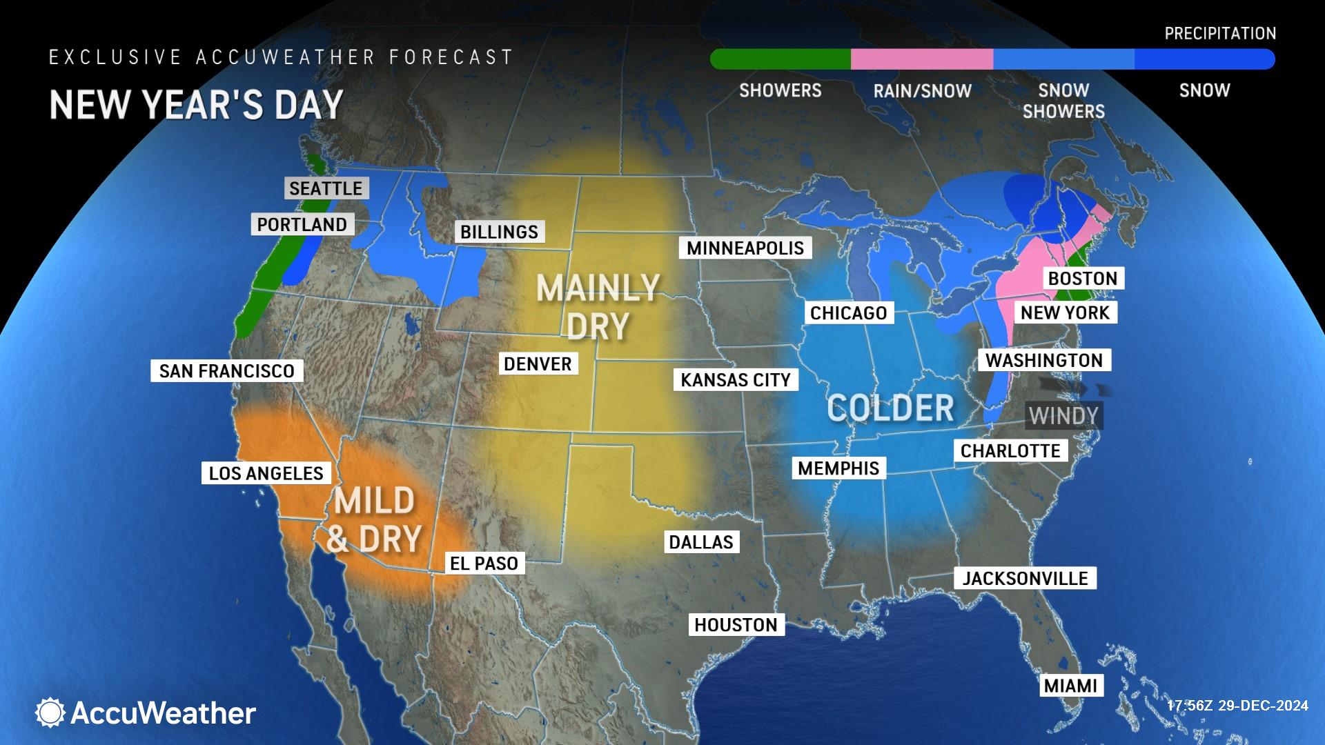
For New Year’s Day, AccuWeather is forecasting a wintry mix in parts of the Northeast, colder air in the Ohio Valley and parts of the Midwest, as well as and rain and mountain snow in pockets of the Northwest.
Bitterly cold and wintry weather returns to the East Coast
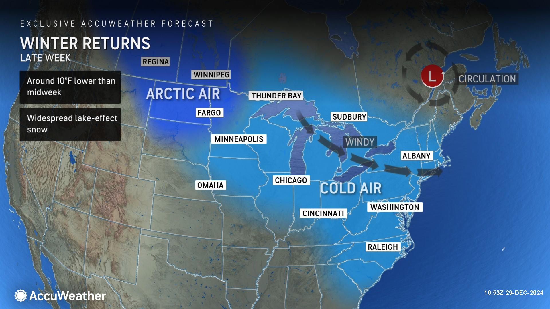
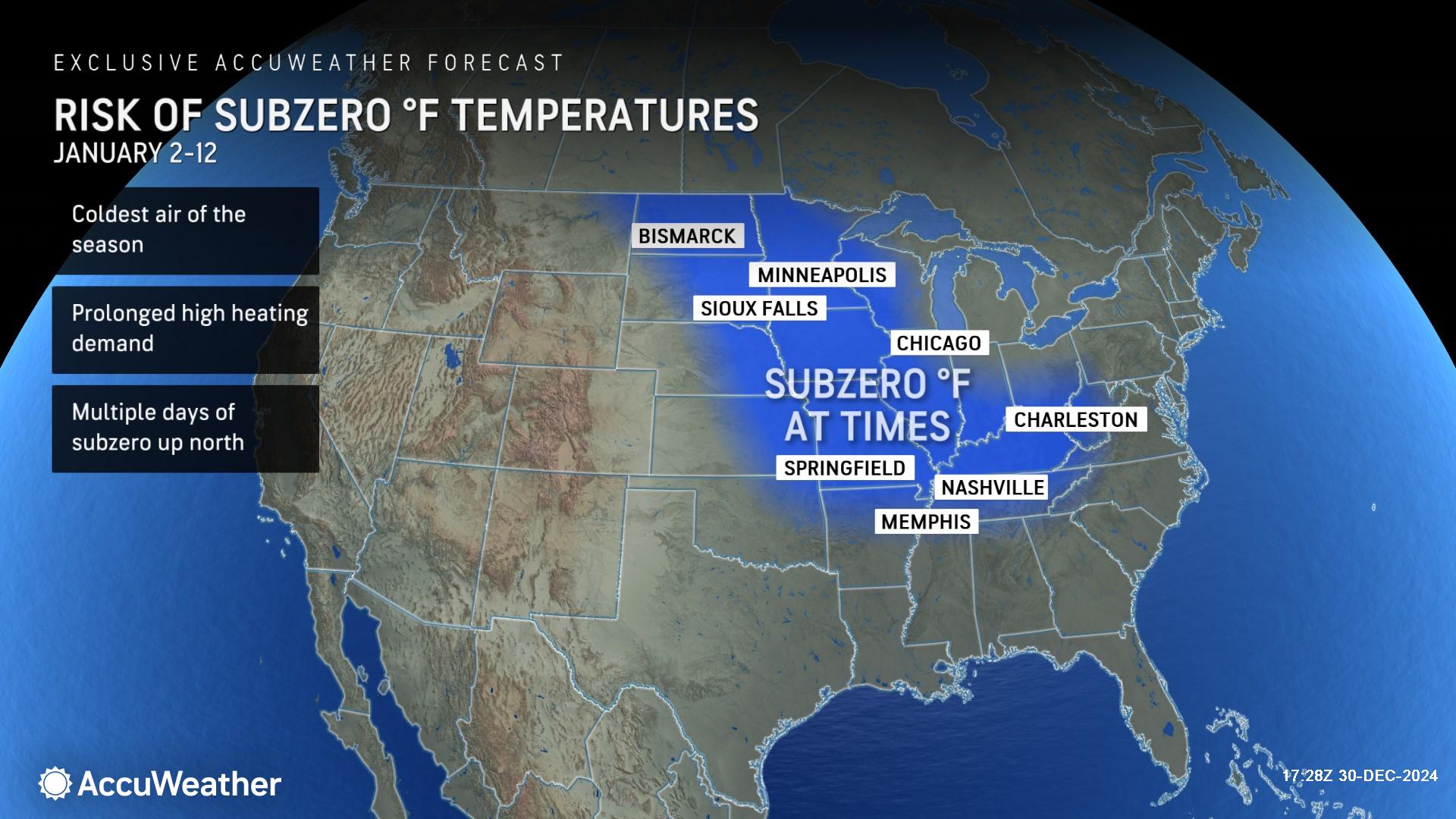
Following a stretch of milder air across much of the East Coast, AccuWeather long-range experts say several blasts of Arctic air will bring drastically colder weather to the region during the first half of January.
“Bitterly cold air will make a big return to the East Coast starting this weekend. This could end up being the coldest January since 2011 for the U.S. as a whole,” AccuWeather Lead Long-Range Expert Paul Pastelok said.
The severity of the cold air could be dangerous, damaging, and disruptive in some places and is expected to create a surge in demand for heating, leading to higher energy bills.
“There is going to be bitterly cold air sweeping across much of the country by the middle of next week,” Rayno said. “Widespread cold air will bring subzero temperatures to the northern Plains and Upper Midwest next week. It will be incredibly cold in Minneapolis and Chicago.”
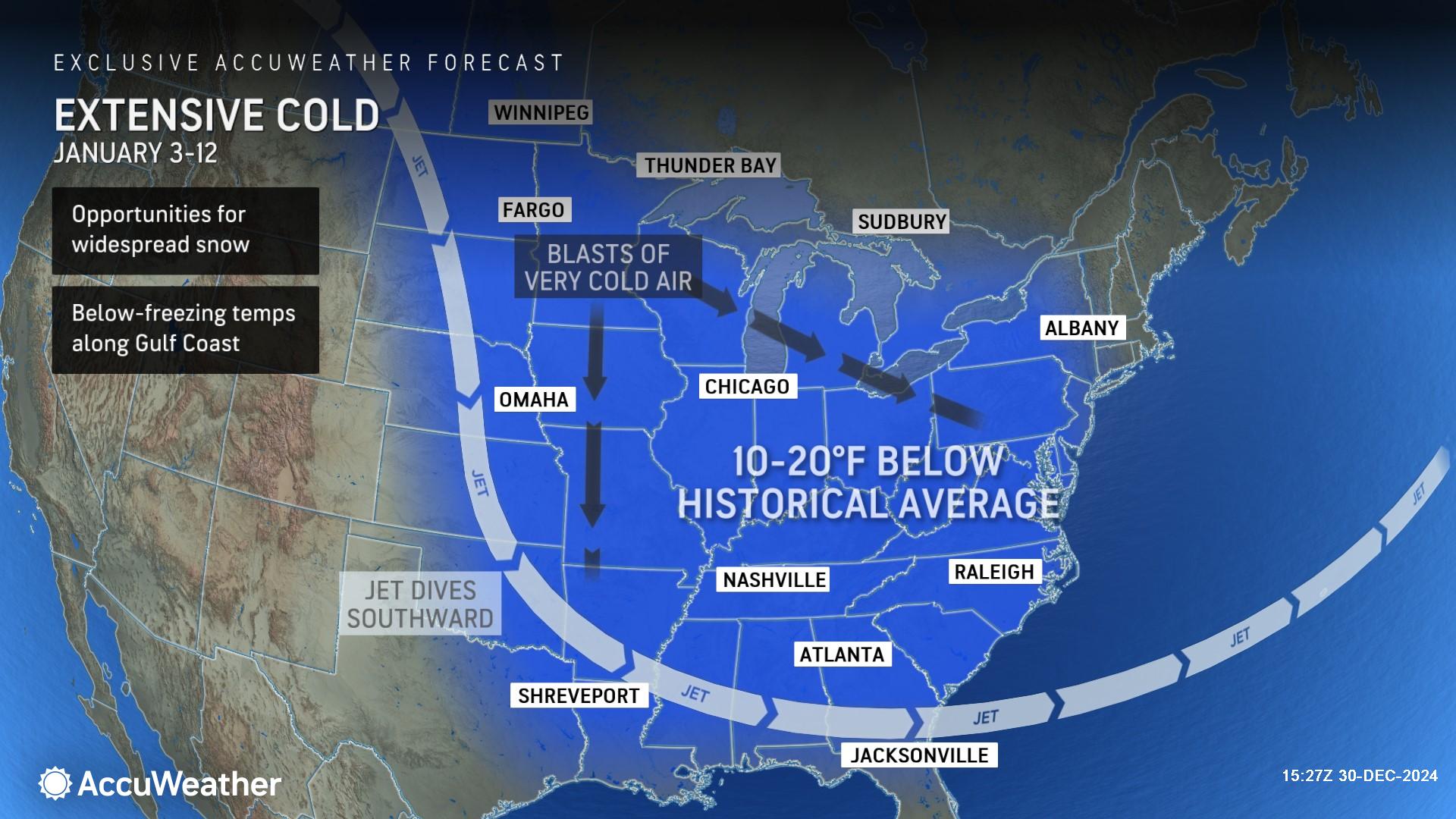
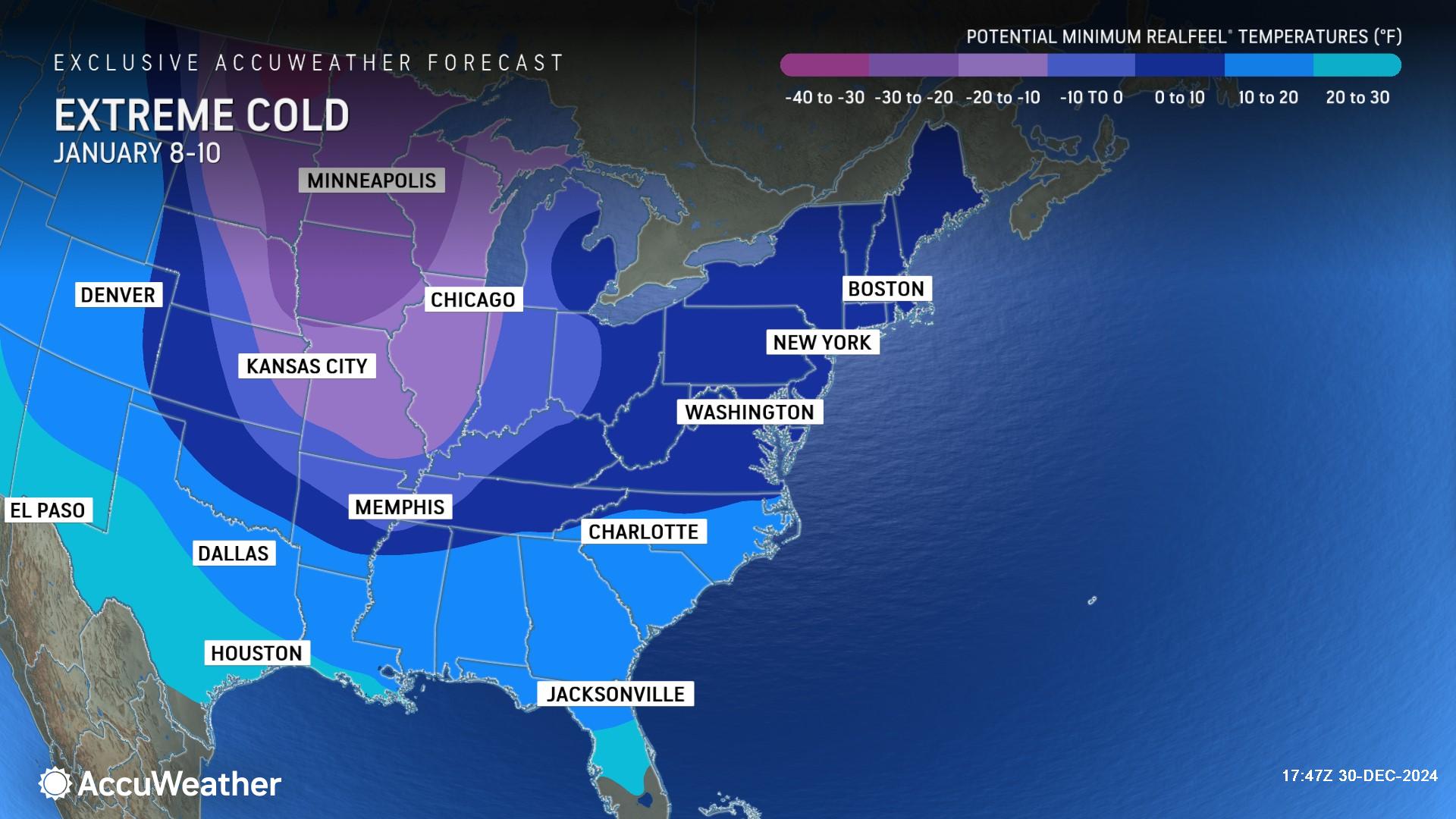
AccuWeather long-range experts say blasts of Arctic air could drop temperatures 10-20 degrees or more below the historical average next week across much of the eastern and central United States. As the cold air deepens and tightens its grip before mid-January, subzero temperatures are expected across a large swath of the Midwest and Ohio Valley.
Should the cold wave evolve to its full potential, temperature departures could plunge 30-40 degrees below the historical average from the northern Plains and Midwest to the interior Southeast during the first to second full week of January. Cold air of this magnitude over hundreds of thousands of square miles could result in power grid issues with the potential for rolling blackouts.
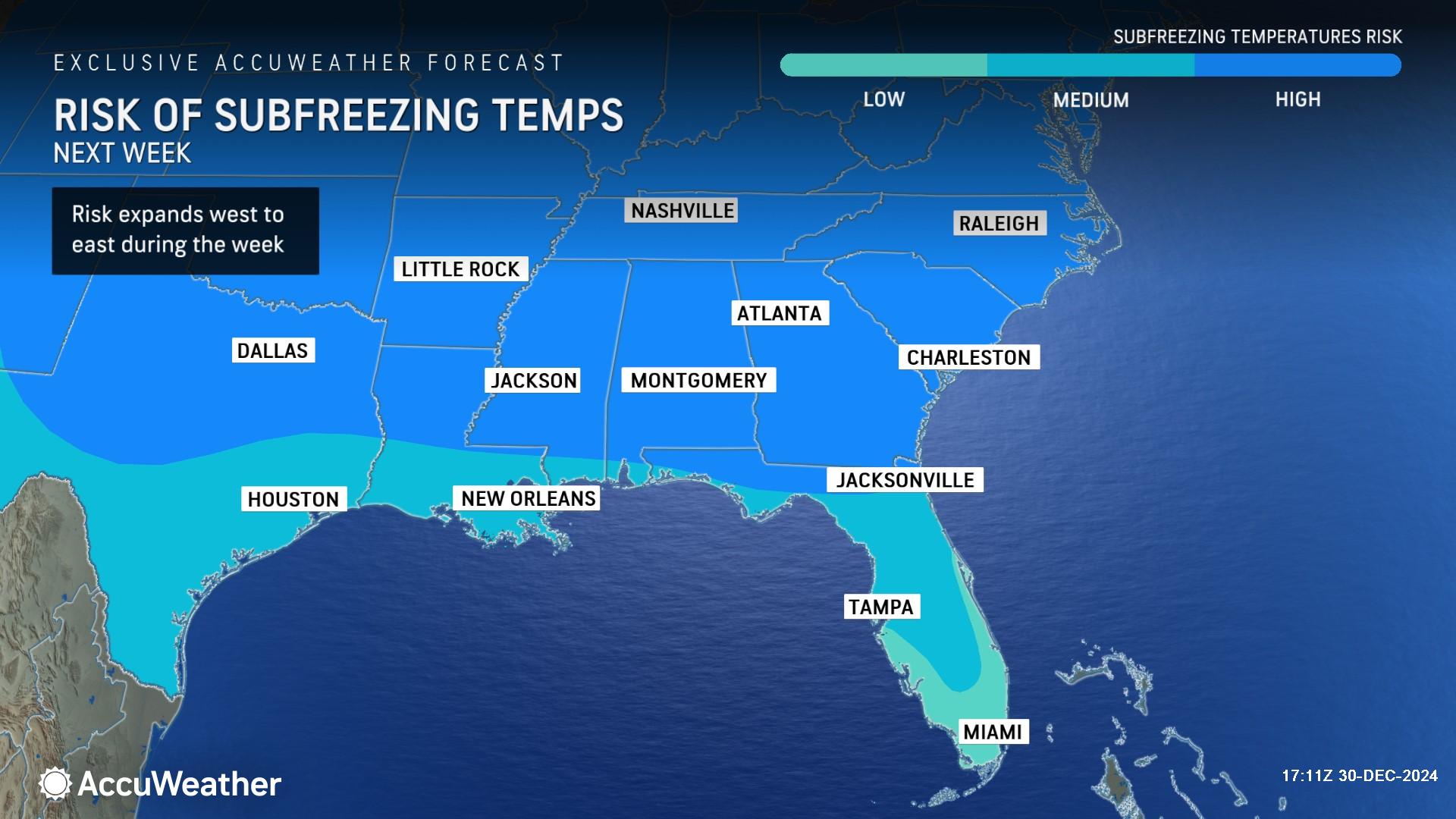
“The historic February 2021 arctic blast caused millions of power outages and tens of billions of dollars in damage and economic loss. This upcoming cold wave is expected to be focused farther east and may spare Texas the worst conditions, like those experienced in 2021. However, the first half of January 2025 has the potential to be remembered across the eastern half of the U.S. as a brutally cold stretch with subfreezing temperatures all the way to the Gulf Coast which is dangerous, especially in places that do not typically experience freezing conditions,” AccuWeather Senior Director of Forecasting Operations Dan DePodwin said. “The Southeast has experienced a run of Januarys with warmer than- -average or near-historical-average temperatures. January 2025 could end up being the coldest since January 2018 in this region. In an extreme scenario where the cold lingers past the middle of January, it could be the coldest January since 2014.”
As much colder air blasts across the Great Lakes and into the Northeast in waves, it will unleash shifting bands of heavy lake-effect snow that can hamper travel, increase the risk of multiple vehicle pileups, and even close some major highways at times. Multiple feet of snow may bury some communities where the bands of heaviest lake-effect snow persist.
Winter storms on the horizon
AccuWeather long-range experts say the upcoming pattern is conducive to supporting storms that could bring snow or a wintry mix to the Northeast and mid-Atlantic, instead of plain rain.
The first storm could bring snow and ice to parts of the Midwest, Ohio Valley, and Northeast starting Sunday through early next week.
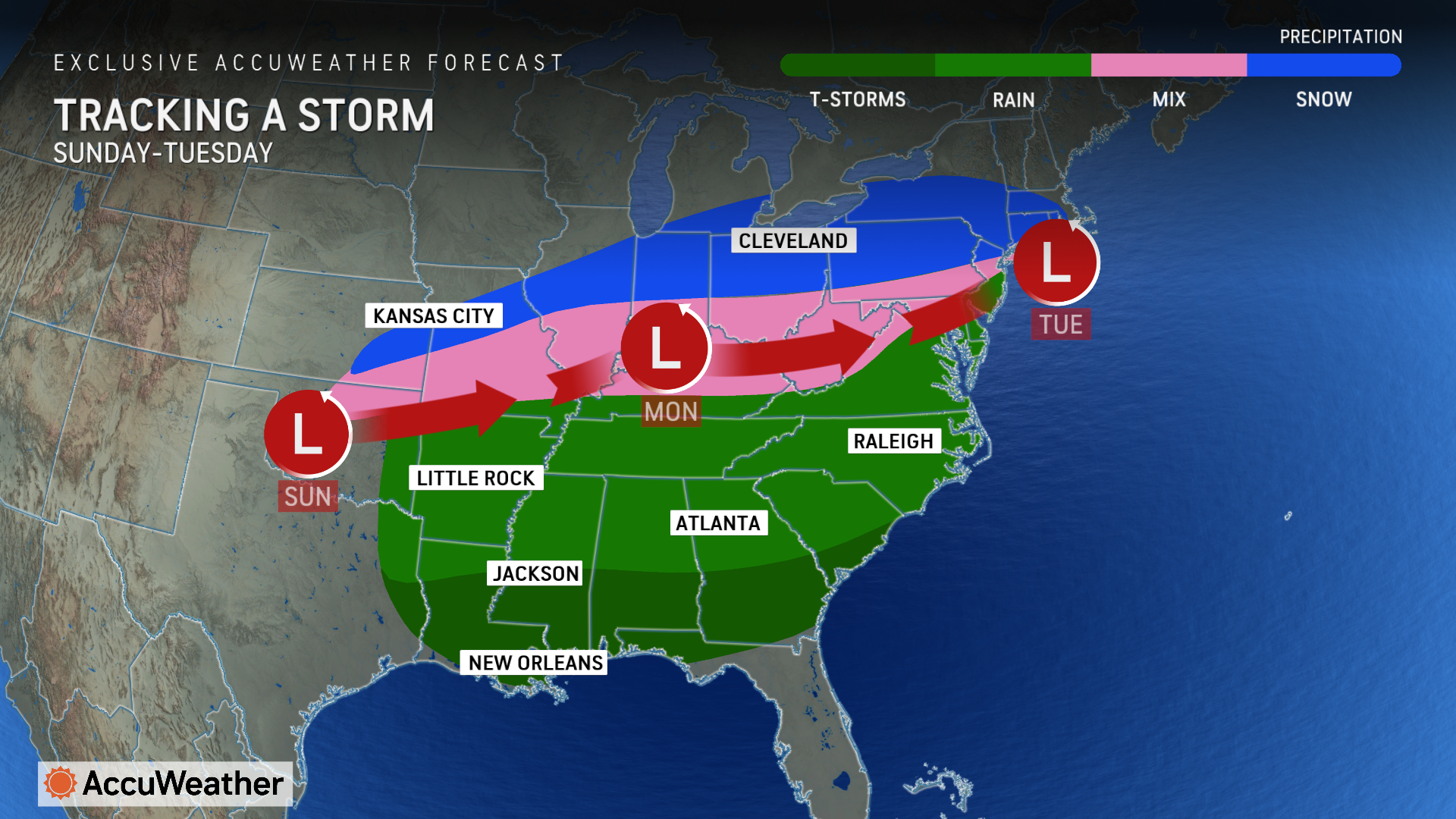
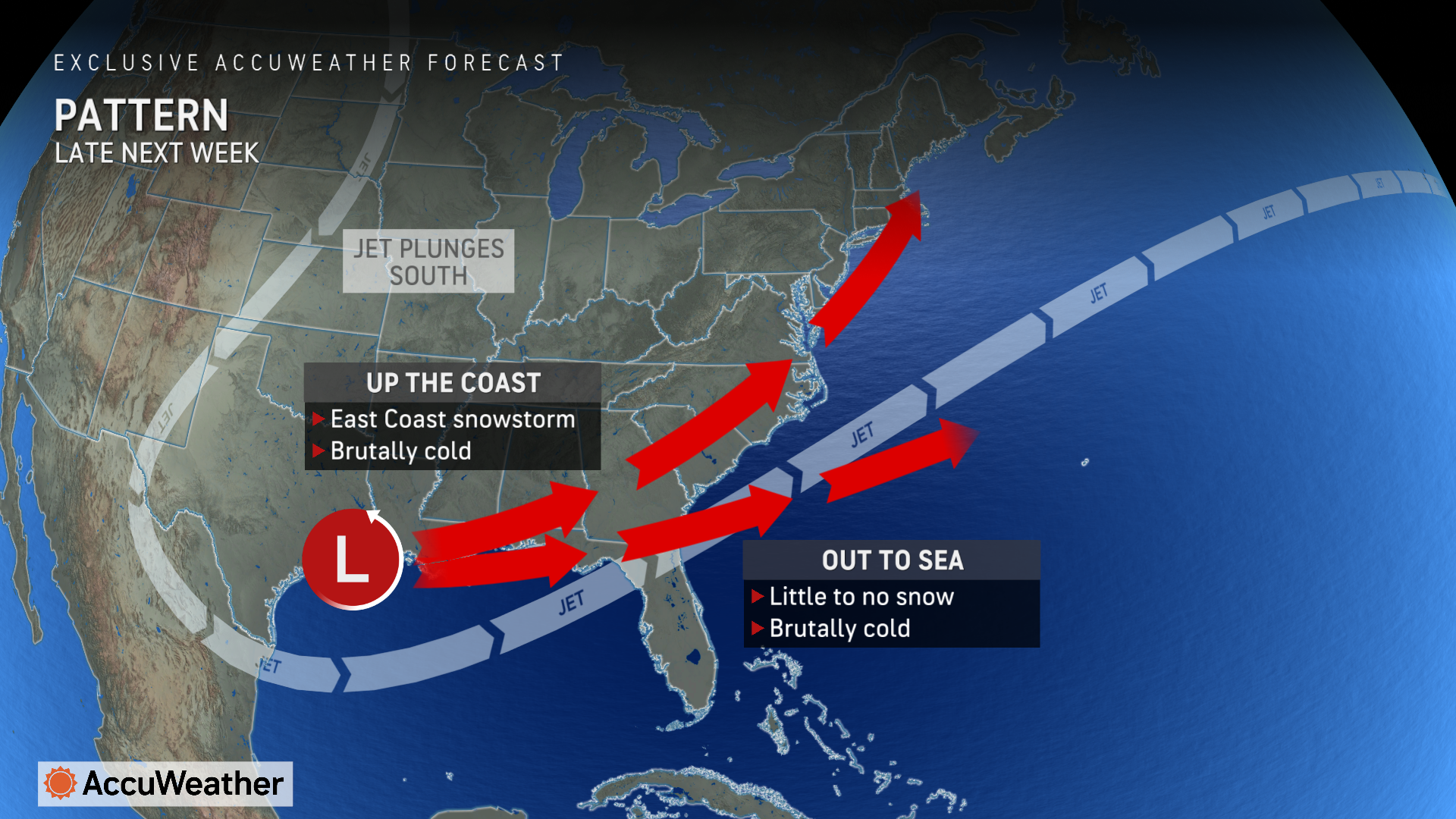
AccuWeather long-range experts are monitoring the potential of a second storm that could evolve into an East Coast snowstorm later next week.
Accumulating snow could impact parts of the Midwest, Northeast, and Mid-Atlantic, possibly reaching the South Central and Southeast states.
Major metro areas such as Chicago, Boston, New York City, Philadelphia, Washington, D.C., as well as Charlotte and Atlanta, could be on the receiving end of accumulating snow during the pattern.
Snow or ice could reach areas as far south as Houston and New Orleans.
“This is some seriously cold air that could plunge as far south as Texas. There could be a potential for snow and ice in parts of Texas late next week,” Rayno said.
This type of weather pattern, occurring during some of the historically coldest days of the winter, has a significant chance of leading to major travel disruptions.
“Given the setup as we see it now, the anchor for the cold air may be centered over the Midwest rather than the Northeast,” AccuWeather Senior Meteorologist Brett Anderson said. “The pattern favors storms weakening as they push into the Ohio Valley but then re-form along the mid-Atlantic coast. An atmospheric roadblock over eastern Canada may prevent the storms from traveling too far to the north, and the main snow threats may shift farther south than what has occurred so far this winter. Accumulating snow could end up over part of the mid-Atlantic region and interior Southeast for part of the first half of January.”
Waves of cold air reaching the South Central and Southeast states could lead to problems with frozen pipes and water damage in poorly insulated or exposed homes and buildings during this pattern.
“We will be closely monitoring how far south the cold air is able to press in crop-vulnerable areas such as Florida and Texas,” AccuWeather Meteorologist Alex DaSilva said. “It is possible that freezing temperatures may reach these far southern locations in the pattern during the first half of January.”